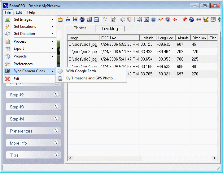
Sync Camera and GPS clock

robogeo.com banner

Camera Clock

click on 'File', 'Edit' or 'Help' to navigate the documentation
click on File, Edit and Help above to navigate
 

Sync Camera Clock and GPS Using Google Earth

This feature allows you to automatically set the UtcTimeBias and CameraOffset preference settings. To use it, you must be geocoding photos from a GPS tracklog and at least one of the images must have a known location.

Upon selecting, the photos and the tracklog will load into Google Earth where you can manually position one of the photos to its known location. RoboGEO will then calculate the two preference settings so that they can be applied to the rest of the photos.

You can quickly see your current CameraOffset and UtcTimeBias settings by hovering your mouse over the applicable button.

After setting UtcTimeBias and/or CameraOffset and upon unloading the Camera Clock form, you'll be prompted whether to reload the tracklog. Select Yes and all of your photos should be correctly geocoded with the new settings applied. If not, see the troubleshooting page for more information.

Sync Camera Clock and GPS Using a Picture

This option allows you to automate the setting of UtcTimeBias and CameraOffset items by specifying the timezone and by specifying the camera error.


© 2003-2024 Pretek, Inc.
File pull-down menu Edit pull-down menu Help pull-down menu Home Select photos to geocode Get photo locations Photo dictation Process images Export maps Project files Program preferences Camera Clock Exit documentation Sync Clock and GPS Using Google Earth Sync Clock and GPS Using a Picture of the GPS