NMEA Data

robogeo.com banner

Import or Log NMEA Sentences

click on 'File', 'Edit' or 'Help' to navigate the documentation
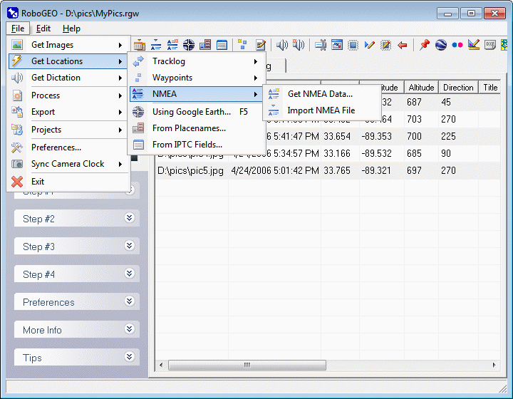
click on File, Edit and Help above to navigate
 

Download NMEA Data

Select this option to create a NMEA data file. On the resulting screen, you'll need to specify the COM port and baud rate. Click the 'Start' button to begin logging NMEA data from the GPS receiver. Click the 'Stop' button when you're done.

The GPS's interface must be set to any version of NMEA 0183 with the appropriate baud rate. The connection to the computer must be a serial RS-232. USB connections are not supported.

Import a NMEA Data File

Select this option to import tracklog files created by a Sony GPS-CS1 GPS, a GiSTEQ PhotoTrackr, a Solmeta Geotagger Pro, or any other type of GPS data logger that outputs NMEA sentences. Except for JTR files, the file must be per NMEA 0183. A typical NMEA file looks like:

$GPRMC,080935,A,3512.589,N,08449.304,W,000.0,360.0,230806,004.1,W*79
$GPRMB,A,,,,,,,,,,,,V*71
$GPGGA,080935,3512.589,N,08449.304,W,1,08,2.0,311.4,M,-31.4,M,,*76
$GPGSA,A,3,02,,06,,10,18,21,26,,29,30,,3.2,2.0,3.0*31
$GPGSV,3,1,11,02,29,090,42,05,03,202,00,06,53,297,46,08,00,074,00*7E
$GPGSV,3,2,11,10,53,036,46,18,10,239,34,21,15,294,37,26,42,159,45*7D
$GPGSV,3,3,11,27,00,048,00,29,51,146,46,30,16,237,37,,,,*48
$PGRME,15.0,M,22.5,M,15.0,M*1B
$GPGLL,3512.589,N,08449.304,W,080935,A*38
$PGRMZ,1021,f,3*29
$PGRMM,WGS 84*06
$GPBOD,,T,,M,,*47
$GPRTE,1,1,c,0*07
$GPRMC,080937,A,3512.589,N,08449.304,W,000.0,360.0,230806,004.1,W*7B
$GPRMB,A,,,,,,,,,,,,V*71
$GPGGA,080937,3512.589,N,08449.304,W,1,08,2.0,311.4,M,-31.4,M,,*74
etc...

The latitude, longitude, and time values are obtained from the $GPRMC sentences. For Garmin units only, the altitude and datum values are obtained from the $PGRMZ and $PGRMM sentences, respectively. If $GPGGA sentences exist, the altitude information is obtained from that. Directional information is obtained from the $PTNTHPR sentences (heading, pitch, and roll) when you're using a unit that's capable of recording the camera direction, like the Solmeta Geotagger Pro. Other sentence types are ignored.

The program also supports the private sentences contained in a Magellan eXplorist tracklog file. These files have a .LOG extension and begin with $PMGNTRK. A typical file looks like:

$PMGNTRK,3406.836,N,11752.882,W,00185,M,003445.80,A,,220705*6C
$PMGNTRK,3406.860,N,11752.882,W,00178,M,003506.78,A,,220705*6C
$PMGNTRK,3407.680,N,11752.873,W,00185,M,003825.81,A,,220705*6B
$PMGNTRK,3407.703,N,11752.873,W,00185,M,003834.31,A,,220705*6A
$PMGNTRK,3407.714,N,11752.873,W,00185,M,003839.81,A,,220705*6A
etc...

Imported NMEA files can have any file extension, but .nmea, .nme, .gps, .txt, and .log are the most common.

You can view the imported tracklog data by selecting the main grid's 'Tracklog' tab. This is handy if you need to diagnose why you got unexpected results when geocoding photos.

You can automate the import of a NMEA file by specifying it on the command line.

JTR files use a proprietary format where each line contains a $HCHDG sentence appended to the end of a $GPRMC sentence. Each line corresponds to a specific image. JTR files are created by the Jelbert GeoTagger device.


© 2003-2024 Pretek, Inc.
File pull-down menu Edit pull-down menu Help pull-down menu Home Select photos to geocode Get photo locations Photo dictation Process images Export maps Project files Program preferences Camera Clock Exit documentation Geocode from a GPS tracklog Geocode from waypoints Load or log NMEA sentence data Geocode photos using Google Earth Geocode photos from placenames Geocode photos from the IPTC Log NMEA data Import NMEA data file