|
Geocoding photos from waypoints requires more work on your end, both in the field and at the computer, but it's generally more reliable than using a GPS tracklog since you don't have to worry about the potential issues associated with converting the local times of photos to the UTC times in the tracklog. It's especially reliable if you enter the left-hand portion of the photo filename into the waypoint comment field when the photo is taken. That allows the program to automatically assign the correct waypoint to each photo, as described below.
You can assign waypoint identifiers and comments to image titles and descriptions by setting the appropriate options. These can then be written to the EXIF per the options that you specify.
You won't be able to determine the photo direction by using the PhotoDirFromTracklog option or by entering relative directions. That requires a tracklog. The best strategy for recording the photo directions when using waypoints is to save them into the waypoint comment field and then later manually enter them. If you use a magnetic compass to obtain these directions, be sure to specify the MagneticDeclination value before entering the directions into the main grid.
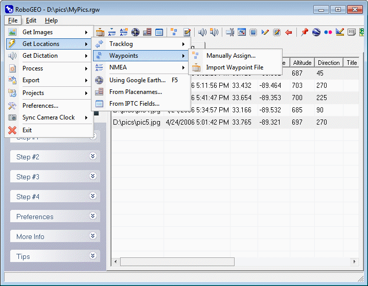
This option allows you to manually assign a waypoint's location to each photo. The waypoints can be obtained either by downloading them direct from a Garmin GPS unit or by importing them from a GPX file.
When the 'Select Waypoint' form loads, you'll need to load the waypoints. You can do this either by downloading them from a Garmin GPS, by importing a GPX file, or by importing a shapefile. If you import a shapefile, you'll need to specify the attribute field names that contain the latitude, longitude, timestamp, identifier, and comment. The currently selected images will be on the left and the GPS waypoints, upon loading, will be on the right. For each image, select the corresponding waypoint. To undo a selection, click the 'Cancel' button. To cycle through the images, click the 'Next' and 'Back' buttons. When done, click the 'Done' button.
To use this method you must record a waypoint at each photo location. If the left-hand portion of the corresponding image filename exists in either the waypoint identifier or in the waypoint comment, the program will automatically select that waypoint when the image loads if the image has not been previously geocoded. This allows you to semi-automate the process of assigning waypoints to photos.
In the field, a typical workflow involves:
1. Take the photo. Assume the file name is 'IMG 0014.jpg'
2. Enter anything for the waypoint identifier.
3. Enter 'img 0014' for the waypoint comment.
Since the left-hand portion of the image's filename (img 0014) exists in the waypoint comment field, you'll be able to automatically assign the waypoint to the image without you having to manually select it. Searches are not case sensitive. Note that you can match on the waypoint identifier too and when you do that, there's no need to enter anything for the comment.
Unlike the method of manually assigning waypoint locations to each photo, this allows you to automate the process.
Each waypoint in the imported GPX file must have a time and that time must be in a <time> child element. Note that some Garmin GPS models write the current time to the comment field when a waypoint is recorded. This time is not used by RoboGEO or by other compliant programs because the Garmin Protocol does not allow it.
Upon importing the GPX waypoint file, each photo is geocoded using the location of the waypoint having a timestamp that's closest to the photo's EXIF timestamp and, unlike imported tracklogs, the program does not perform any type of interpolation to determine the final photo location.
The WaypointImageMaxTimeDifference preference option allows you to specify the maximum time difference between the EXIF and waypoint timestamps.
|